Improving Stealth Capabilities for Undersea Vehicles
CAMBRIDGE, MA – The U.S. military’s unmanned underwater vehicles (UUVs) depend on stealth as they conduct surveillance and reconnaissance and other missions in the deep oceans. With GPS signals unable to penetrate the ocean’s surface, these UUVs can rely on inertial sensors to provide acceptable positioning information during short missions. On longer missions, however, inertial sensors accumulate error, forcing the vehicles to risk exposing themselves to enemies as they periodically surface to obtain a GPS fix.
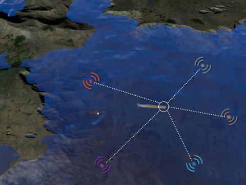
The Defense Advanced Research Projects Agency (DARPA) is addressing this issue by funding the development of a small number of acoustic transmitters that can be anchored to fixed locations around ocean basins to serve as an undersea navigation constellation. By measuring its range to multiple signals emanating from known coordinates, an undersea vehicle can operate continuously with accurate navigation information without needing to surface for GPS fixes or to use high cost inertial systems that are typical of current UUVs. DARPA awarded a contract on March 15 to a Draper-led team to begin development of a solution for the Positioning System for Deep Ocean Navigation (POSYDON).
“Stealth is a critical capability for counter-anti-access/area denial (C-A2AD) missions,” said Joel Parry, Draper’s maritime warfare and intelligence, surveillance and reconnaissance (ISR) lead. “Giving UUVs GPS-like accuracy anywhere in the ocean, without the need for surfacing or active signal emissions, will significantly boost the chances of success of the types of missions that UUVs take on today, and will enable them to conduct missions that would be considered too risky today because of the chance of detection.”
Draper’s work on POSYDON begins by developing high-fidelity models of how the positioning signals will travel through the ocean as well as developing the signal waveforms. DARPA’s current plans for the program call for at-sea demonstration of the system in 2018.
Draper’s work on this program leverages its proven technology used by U.S. government customers to enable systems such as guided munitions and highly maneuverable aircraft to maintain their lock on satellite signals, as well as Draper solutions that enable users to acquire satellite signals indoors and in other areas where a conventional receiver would struggle.
The engineering solution used on POSYDON could also be used for civilian applications, such as underwater surveys, helping avert delays while the vehicle surfaces and errors that can occur between GPS fixes, Parry said.
The Draper-led team includes the Massachusetts Institute of Technology (MIT); the Scripps Institute of Oceanography at the University of California, San Diego; Intific Inc.; Riptide Autonomous Solutions; and Hydroacoustics Inc.
Released May 10, 2016

