NASA Turns to Draper for Microsatellite Technology
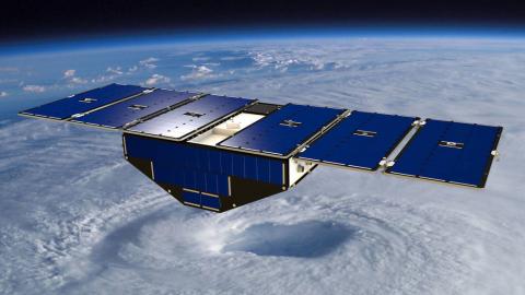
CAMBRIDGE, MA – NASA’s launch of eight microsatellites in December under the Cyclone Global Navigation Satellite System (CYGNSS) mission promises to be more than just another milestone in the U.S. space and satellite program. Once in orbit, these tiny satellites will usher in a new era of improved understanding and forecasting of hurricanes, typhoons and tropical storms all over the globe.
Several institutions collaborated to bring the CYGNSS mission to life. The University of Michigan is directing the CYGNSS mission for NASA, including satellite design and production and science data processing. The CYGNSS constellation will be deployed into low-Earth orbit with successive satellites passing over the same region approximately every 12 minutes. The Southwest Research Institute in San Antonio is building and testing the CYGNSS microsatellites and will host the mission operations center at its Boulder, Colo. location.
CYGNSS is a constellation of eight microsatellites that utilizes a limited set of sensors to determine in which direction the spacecraft is pointing and a limited set of actuators to control that pointing. Draper developed the unique Attitude Determination and Control System (ADCS) that is responsible for all spacecraft closed-loop functionality spanning stabilization, Sun acquisition and hold and pointing control and momentum management for all mission functions subject to the limitations arising from the small size of the CYGNSS spacecraft. This ADCS flight software leverages Draper’s extensive spacecraft Guidance Navigation and Control (GN&C), heritage dating back more than 50 years.
Once in low-Earth orbit, the microsatellites promise to improve current hurricane research and forecasting methods. Typically, the National Oceanic and Atmospheric Administration (NOAA) measures the wind magnitude of a hurricane using specially equipped aircraft that fly directly through the eye of a storm, collecting data during an 8-10 hour mission. While these planes collect accurate data about the storm in one time and place, hurricane magnitude can often shift drastically over time.
A far more accurate approach will be implemented on December 15, 2016, when NASA launches the CYGNSS mission. The constellation of eight microsatellites will do what a single aircraft can’t in terms of measuring surface wind speeds inside hurricanes and tropical cyclones more frequently, which will help to improve understanding and forecasting of how these deadly storms develop.
CYGNSS’s approach promises to bring huge benefits. By using a constellation of small, orbiting satellites, wind-speed data can be collected nearly continuously about an entire tropical hurricane, enabling more accurate categorization of it. Better information about the storm will help those who may be in the path of the storm to better prepare for when it makes landfall.
“Microsatellites represent an exciting new chapter in space systems and technology, and at Draper, we are seeing interest in satellites from customers all along the value chain,” said Seamus Tuohy, Director of Space Systems at Draper. “Cubesats, chipsats and microsats provide new ways to bring space closer to Earth—and new ways to integrate satellite data and imagery into business, government, philanthropy and investment decisions. For Draper, CYGNSS is a welcome milestone in a story about satellites that’s just beginning.”
Building on its long history, Draper continues to design and develop the world’s most accurate and reliable guidance systems. Draper’s achievements include the design and development of guidance systems that guided the Apollo astronauts to the Moon and back safely to Earth, every time. Draper has contributed to the development of inertial sensors, software and other systems for the GN&C of commercial and military aircraft, submarines, strategic and tactical missiles, spacecraft and unmanned vehicles. Draper continues to be a key member in programs that include the International Space Station and NASA’s Origins, Spectral Interpretation, Resource Identification-Regolith Explorer.
Released December 16, 2016

